The Early Bronze Age, corresponding to the 3rd millennium BCE, is a significant moment in the formation of complex societies in Mesopotamia. Indeed, it witnesses not only the beginning of massive urbanization in this part of the world, but also the birth of a major political change through the transition from small independent kingship via a city-state system to a territorial unification under the Akkadian dynasty, around 2350 BCE, followed by the coexistence of important kingdoms, the kingdom of Ur being the best known, which laid the foundations of a bureaucratic system allowing the control of distant territories, foreshadowing the Assyrian and Babylonian empires.
Mesopotamia, and more particularly the region corresponding to modern Iraq, has been the subject of archaeological excavations for almost two centuries, though these have been very unequally distributed, both geographically and chronologically. Indeed, many regions have not been sufficiently explored, thus providing only a partial picture of the complex social and political dynamics of this vast territory, which is composed of several regional entities whose populations regularly came into contact with each other, contributing to the production of a more or less homogeneous culture. Iraqi Kurdistan is one of those regional entities under-studied by past archaeological research. In recent years, thanks to favourable political and security conditions, Iraqi Kurdistan has become the subject of new research, with more than forty archaeological projects (Kopanias & MacGinnis 2016). These projects are welcome since, even though Iraqi Kurdistan remains very little known, it is home to an important number of ancient sites. However, the new research data from the sites being explored is somewhat unbalanced from the point of view of their geographical and chronological distribution since the projects focus mainly either on the 4th millennium, known to be the period which saw the appearance of so-called complex societies, or on the 2nd and 1st millennia BCE, which saw the birth and apogee of the Assyrian empire, whose geographical heart was located around the prestigious sites of Nineveh, Khorsabad, Nimrud and Assur. The 3rd millennium, which corresponds to the Early Bronze Age, is but poorly documented and surely needs a reassessment.
Regarding the chronology of this period, today scholars can rely on one major recent work, i.e. the publication of the Arcane series in 2019, which presents the first attempt at a better understanding and harmonization of the archaeological data of the Tigris region, encompassing Iraqi Kurdistan, the southern edge of modern Turkey and the northern part of Federal Iraq, reaching as far as the site of Assur (Rova 2019). Unfortunately, except for the sites of Basmusian and Qasr Shemamok, none of the sites explored the last ten years were considered in this first synthesis. Due to a relative absence of historical documents and the necessity of harmonizing the whole region, the Arcane work divides the Early Bronze Age period into nine phases: the first four, ETG1 to 4,(1) from 3100 to around 2600 BCE, encompass the first half of the 3rd millennium, which is mostly characterized by ceramic cultures and for which there is no political or historical evidence. For this particular period in the northwestern part of Iraqi Kurdistan, one should mention the work that has been carried out on the Ninevite 5 ceramic culture (Rova & Weiss 2003). Then comes ETG 5, roughly between 2600 and 2400 BCE, which might correspond to a period of transition that is barely understood through archaeological documentation, though the first mentions in textual sources appear which could attest to some local kingdoms. Between ETG 6 and 8, i.e. between 2350 and 2100 BCE is the period of Akkadian supremacy and fall, and the last phase, ETG 9, from 2100 and 2000 BCE, represents the second rise of local kingdoms, most of them having hostile relations with the southern Mesopotamian kingdom of Ur. The textual sources for the Early Bronze Age are scarce but have been intensively studied (Ahmad 2012; Sallaberger & Schrakamp 2015; Maiocchi 2019). Since the work of the Arcane group, no attempt at harmonization for the whole region of Iraqi Kurdistan has been made, but one should mention the work of the Assyrian Landscape Research Group intended to harmonize the ceramic typology, based on the fieldwork of four major survey projects since the beginning of the 2010: the Eastern Habur Archaeological Survey (EHAS, directed by Peter Pfälzner, University of Tübingen) (Pfälzner & Sconzo 2015; 2016a; 2016b), the Land of Niniveh Archaeological Project (LoNAP, directed by Daniele Morandi Bonacossi, University of Udine) (Morandi Bonacosi & Iamoni 2015), the Upper Greater Zab Archaeological Reconnaissance (UGZAR, directed by Rafal Kolinski, Adam Mickiewicz University) (Kolinski 2017; 2018; 2019), and the Erbil Plain Archaeological Survey (EPAS, directed by Jason Ur, Harvard University) (Ur et al. 2013; Ur & Giraud 2020). Their periodization is based on previous work, at the end of the 1980s, in the Sinjar area by the North Jezirah Project (NJP, directed by Tony Wilkinson & David Tucker, British School of Archaeology in Iraq) (Wilkinson & Tucker 1995).

Fig. 1: Map of the sites mentioned in the text (Couturaud & Sauvage 2020)
The purpose of this paper is to synthesize the data available for the Early Bronze Age in Iraqi Kurdistan (Fig. 1). Of course, these arbitrary geographical limits do not make sense for antiquity. Moreover, the point here is not to gather exhaustively all the data collected by the archaeological expeditions that have been working for some years in this part of Iraq. Indeed, research is still ongoing; it will take years to fully understand the ins and outs of the societies living there during the 3rd millennium and to be able to understand this data in light of what is known of the neighbouring regions, such as Syrian Jezirah, Diyala, southern Mesopotamia and the Anatolian and Iranian plateaus. Still, this first attempt allows us to see how the work carried out until now has evolved and helps to establish an initial assessment of our knowledge of this period.
First half of the Early Bronze Age (3000‒2600 BCE)
The beginnings of urbanization occur during the Late Chalcolithic period (3900‒3000 BCE), which attests to a growth in the numbers of settlements. However, some survey programs, such as LoNAP and EHAS in the northwest of Iraqi Kurdistan, or even in the Shahrizor plain in the southeastern area, show that the beginning of the Early Bronze Age witnesses a drop in occupation (Morandi Bonacossi & Iamoni 2015: 23; Pfalzner & Sconzo 2015: 112; Altaweel et al. 2012: 25), which is not the case in the Erbil plain, according to the results of the EPAS program (Ur & Giraud 2020: 66-68). Based on the current state of research, it remains difficult to explain the low number of sherds and to understand settlement in this region, or the societies and their material culture, beyond pottery, especially since there is no textual documentation to help recount a political history of this period.
Hence, the beginning of the Early Bronze Age during the first part of the 3rd millennium is characterized by its ceramic assemblage, Ninevite 5, first discovered on the site of Nineveh, mostly present in the areas of Duhok and Erbil and particularly well documented by the excavations in the Lake Mosul area (Rova & Weiss 2003). The heart of this culture was certainly located in the southern areas of Duhok and Erbil (Lawecka 2016). Some scholars talk about the existence of a Ninevite 5 ‘culture’ (Akkerman & Schwartz 2003: 211-224; Forest 2003), which has been questioned (Roaf 2003). Indeed, it seems that apart from the typical decorated ceramics (Fig. 2), this period has no distinctive features, whether architecture or artefacts. Admittedly, there are large sites that have provided other remains, but mostly located in Syria. As for Iraqi Kurdistan, it seems that there is a kind of confusion related to this period. Regarding architecture and material culture apart from ceramics, our knowledge of the Ninevite 5 culture in Iraqi Kurdistan is rather poor but two important sites in the plain of Erbil are yielding interesting levels, namely Bash Tapa and Laskhir, which have both delivered an almost complete sequence for the first half of the Early Bronze Age. At Bash Tapa, a complex system of multiple terraces has been found at the foot of the high mound that has been excavated (Nicolle 2020). At Lashkir, a domestic and artisanal zone have been revealed, producing many finds including animal figurines that are among the earliest ones excavated (Molist et al. 2019).
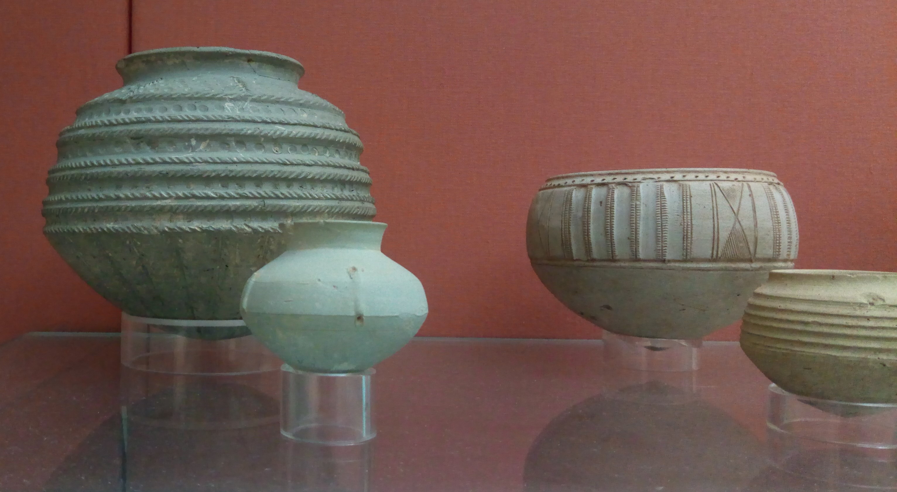
Fig. 2: Ninevite 5 ceramics (Zunkir 2019)
Ninevite 5 pottery sherds were also found further east, in the Kirkuk and Sulaymaniyah areas (Abu Al Soof 1968), in the Ranya plain at the site of Bardastee (Eidem 2015) and at Kani Shaie (Tomé et al. 2016). This site is located in the Bazyan Valley, a very strategic node linked with the control of the routes between the southern Mesopotamian plain and the Iranian plateau. It was occupied from around 4000 until 2500 BCE. The excavations show that during the 4th millennium, the site was certainly an important city, playing the role of a locally significant administrative centre. But levels from the first half of the Early Bronze Age show local developments, perhaps attesting to a form of abandonment, or even a ‘dark age’, with very little evidence of occupation (Tomé et al. 2016: 433). In the southwestern part of Iraqi Kurdistan, other ceramic traditions are known, such as Scarlet Ware, to name but one (Altaweel et al. 2012: 25-26).
Mid-3rd Millennium (2600‒2350 BCE)
The real change in our understanding of ancient societies corresponds with the invention of writing and, more specifically, with the profusion of texts during the second half of the 3rd millennium, as compared to the scanty archaeological data (Fig. 3). Indeed, the period between the second half of the 3rd millennium and the advent of the Akkadian empire around 2350 BCE, remains poorly known: were there local kingdoms? Did the city-state system of southern Mesopotamia also function in the northern region? All is known, from the textual sources, is that this area might somehow correspond to the Subartu, even though the actual limits of this geographical and ideological entity at that time remain more than blurry, it presumably designates the area of northern Mesopotamia in a very general way (Michalowski 1999; Ahmad 2012: 55-60; Maiocchi 2019). Other names of territories may reveal sub-entities included in this Subartu (Ahmad 2012: 51-101; Ziegler 2015): Kakmum, Hamazi (in the region of Sulaymaniyah?), Lullubum (in the Shahrizor Plain or the Tanjero River valley?), Gutium (located in the mountains southeast of Iraqi Kurdistan), and Gasur (at the site of Nuzi, south of Kirkuk). Urbilum is mentioned in a tablet from Ebla, and one can imagine it corresponded to an important urban centre, possibly a city-state (MacGinnis 2014). These texts seem mainly to mention localities or perhaps kingdoms that must have been situated in the southeastern part of Iraqi Kurdistan, probably in the governorates of Erbil and more certainly of Sulaymaniyah and Kirkuk. South of Erbil, sites such as Baqrta and Bash Tapa are also most probably important 3rd millennium sites. Early Bronze Age levels at Baqrta were not excavated, but at that period the site covered nearly 80 hectares (Ur et al. 2012: 97-98). The site of Bash Tapa, meanwhile, revealed that the 3rd millennium occupation was consistent, approaching a height of 5 metres at the base of the high mound (Angevin & Mas 2015: 135). Interestingly, the study of ceramics also reveals a shift in ceramic cultural influences, showing that the site was subjected to influences from the north at the beginning of the 3rd millennium through the Ninevite 5 culture, and then to central and southern Mesopotamian influence in the second half of the 3rd millennium (Mas 2015: 180). Unfortunately, at present, given that only a few tablets have been discovered so far, nothing allows a link to be made between these cities and the political geography described in the texts.

Fig. 3: Cuneiform tablets found at Bassetki, the ancient Mardaman (University of Tubingen 2018)
The texts do not provide any information on cities located in the northwestern part of Iraqi Kurdistan, but there may be at least two large sites that could have played the role of important urban centres. The first is Bassetki (Pfalzner & Qassim 2017; 2018), mainly known in the Akkadian period (see below); the second, Xrab-i Kilasin, is located in the area surveyed by the UGZAR team (Kolinski 2019: 216-239). The site of Gomel should also be mentioned, which has not revealed extensive urban 3rd millennium levels, but there is a large cemetery the finds from which leave no doubt as to the presence of a strong urban elite at the site (Morandi Bonacossi et al. 2018: 99-111). Regarding the general area of the northwestern part of Iraqi Kurdistan, the survey programs show that the occupation pattern in this region in the second half of the 3rd millennium was quite dense, suggesting that some sort of ‘urban revolution’ might have been in progress (Morandi Bonacossi & Iamoni 2015: 23-24). However, the settlement pattern is mostly characterized by a form of rurality, with medium-sized sites.
Akkadian Period (2350-2100 BCE)
Around 2350 BCE, the territory of Mesopotamia came under the control of the Akkadians (Foster 2016; Frayne 1993). We still barely understand the conditions that led to this territorial hegemony. Furthermore, our vision of the creation of this ‘first empire’ is largely dependent on texts left by the kings who created it, and on the results of research carried out mostly in southern Mesopotamia. But what about northern Mesopotamia? While it seems generally accepted that the territory corresponding to present-day Iraqi Kurdistan was subject to the domination of the Akkadian dynasty, most probably under the reign of Naram Sin, the exact details of this domination still elude us. Scattered discoveries, such as that of an Akkadian cylinder seal in Logardan (Paladre 2016), a bronze statuette in Bassetki (Farber 1983) or more generally many ceramics confirm a cultural influence and a form of harmonization of material culture, but the real question of the movement and the place of production of these objects remains difficult to disentangle at present.
This period is mainly known through texts. Several small kingdoms or city-states are still mentioned, such as the kingdoms of Simurrum, located in the Shahrizor plain or further south, in the upper Diyala valley, Gutium, and Karakina (Frayne 1993; Ahmad 2012). Lullubum, also mentioned, is particularly well known since the Naram Sin stele, preserved in the Louvre Museum, shows Lullubi warriors and their king Satuni defeated by Naram Sin on a mountain (Fig. 4). All these small kingdoms were certainly located in the south of Iraqi Kurdistan, therefore closer to Akkad, which explains recurrent references to them in southern textual sources. The site of Logardan, close to the modern town Chechemal, was undoubtedly one of the most important centres of that period and area. The latest excavations show that around 2500 BCE, the city, positioned on a strategic route, was the seat of a significant local power (Vallet 2019). With the arrival of the Akkadian dynasty, this urban centre took on another aspect, transforming into a major industrial centre of ceramic production.

Fig. 4: Victory Stele of Naram Sin (Rama 2020)
In the northwestern part of Iraqi Kurdistan, still mostly absent from the textual sources, the emergence of major urban centres continued. One of the most important and largest cities in the Akkadian period was most certainly the site of Bassetki, where surveys seem to show that at that time, the upper and lower towns were occupied, which makes it an important urban centre, of more than 50 hectares (Pfalzner & Qassim 2017; 2018). It was also an Akkadian post located on the plain bordering the Tigris, a mandatory crossing point on an important communication axis. Recently discovered tablets from the Middle-Assyrian period equate the site to the ancient city of Mardaman (Fig. 3). It could thus correspond to the city of Maridaban, mentioned by Naram Sin (Sallaberger & Schrakamp 2015: 45). The 3rd millennium levels have not yet been reached, but future excavations will hopefully show what type of Akkadian influence there was on the site, which would help in determining whether artefacts such as the famous statue had been imported, possibly from a temple where it was originally located in Akkad itself, or whether it had been made there. That being said, the discovery of many typical Akkadian ceramics during the survey of the site tends to confirm that the city was an Akkadian post, though it should not be forgotten that ceramics, as well as their contents, could travel.
Gutian and Ur III Empires (2200–2000 BCE)
Texts describe the fall of the Akkadian dynasty, defeated by Gutian warriors that came from the mountains (Ahmad 2012: 119-157). They seem to have succeeded in ruling for a time over the previous so-called Akkadian empire, although at the same time some cities might have recovered their autonomy. What remains sure at this point is that even if the reality of the political power of the Guti and its territorial grip escape us, their passage through the political landscape of this time was sufficiently important for there to be a trace of it in the Sumerian King List (Glassner 1993). Future research may be able to explain why: either for the reality of their power or for having put to an end the Akkadian hegemony. Noteworthy is an inscription from a Gutian king, Eridu-Pizir, who launched a raid against Simurrum, Lullubum and Urbilum, whose king, at that time, was Hurrian and named Nirishuha (MacGinnis 2014). Other inscriptions mention other kings of local kingdoms, such as Anubanini, king of Lullubum, and the one on the famous relief discovered near Sarpol-e Zahab, in Iran, in the province of Kermanshah, or Iddi-Sin, king of Simurrum, on the relief of Baiwata (Hassan 2019: 92-108).
The domination of the Gutians was ended by Utu-Hegal, king of Uruk who ruled just before the supremacy of the Ur III empire. He was also the third ruler, after Naram Sin of Akkad and Eridu-Pizir, to use the expression ‘king of the four corners of the world’ (Ahmad 2012).
Relations between the kings of the Ur III period and northern Mesopotamia seem to have been chaotic (Michalowski 2018). For example, it is known that at least two raids took place on the city of Erbil, during the 45th year of Shulgi’s reign and the 2nd year of the reign of Amar-Sin. However, this information is provided by textual sources and the archaeological evidence is much less clear. The site of Kunara, near Sulaymaniyah — and thus certainly included in the Lullubum territory — has revealed levels contemporary with this period, with a monumental building on a stone footing that occupies almost the entire surface of the high mound and that seems to have remained on the same general orientation and organization in the Akkadian and Ur III periods. The excavations have also delivered tablets relating to the trade and conservation of flour, some mentioning an ensi (Tenu et. al. 2019: 59-68; Tenu 2020: 61-68). At Bakr Awa, levels from the end of the Early Bronze Age in the lower town have also revealed large buildings with stone foundations, as in Kunara, which date from the Akkadian or post-Akkadian period, and according to the excavators, one of them could be a temple (Miglus et al. 2013: 62-65).
To the south of Erbil, aside from Bash Tapa, which also had a large occupation by the end of the Early Bronze Age, and Baqrta, already mentioned, one should also mention the neighbouring sites of Qasr Shemamok and Kandara Qal, which are starting to reveal Early Bronze Age levels and should soon provide information about this period (Dolce 2020), as well as the site of Aliawa. All these cities might have been opposed to the kingdom of Ur, as revealed through many texts that mention conflictual relationships with the northern kingdoms. Indeed, the raids of King Shulgi against Urbilum and Shashrum, located around the plain of Rania, show these chaotic relationships. Texts from Ur King Shu Sin also mention kingdoms located in the northwestern part of Iraqi Kurdistan, like Nineveh which King Tish Atal was the vassal of Ur (Macginnis 2017). The reality of the power of the kings of Ur in this area remains hard to grasp, even more so when considering that there were repeated battles against those northern cities and kingdoms. In any case, by the end of the Early Bronze Age, one witnesses the birth of new territorial kingdoms that continued throughout the Middle and Late Bronze Ages.
Excavations at Amyan: A Future Perspective on the Early Bronze Age in Northern Kurdistan?
The image of Iraqi Kurdistan during the Early Bronze Age painted here is still blurry and very incomplete. Several problems arise for the beginning of the period, particularly regarding the question of a standardized culture and the need for a better definition of local ceramic traditions at both the site and micro-regional levels. For the moment, the chronology and its definition using ceramic material is extremely dependent on what is known from neighbouring regions, and it seems that between the northwest and the southeast, disparities remain. Then, beyond ceramics, a whole culture must be defined, and from this point of view, the current excavation projects are probably not advanced enough to provide reliable data. Then, some explanations have to be found regarding the decrease in the number of settlements at the beginning of the 3rd millennium in some of the fertile plains of Iraqi Kurdistan, particularly as it seems to follow a period of intense occupation. Could it be a potential indicator of the absence of strong powers that might have allowed the domination of the kings of Akkad and Ur over the region? Was it due to ecological and environmental problems? Or was there an increase in a nomadic lifestyle that would explain a certain collapse of urban centres?
For the second part of the period, more textual data exist, but most of the texts emanate from the centres of power in the south of Mesopotamia and, to a certain extent, present a distorted reality. Questions remain unanswered: what was the political model of the northern cities of Mesopotamia? And to what does Subartu correspond? Was it recognized as such by its inhabitants?
Also, the reality of Akkadian power and the power of the kings of Ur needs to be understood. To what extent, for instance, did the major urban centres that developed at that time keep a form of autonomy or to what extent were they submitted to the political and cultural influence of the Akkadians? It will also be necessary to draw the borders and the extent of local powers and kingdoms, such as Lullubum or Gutium, and to see how a form of border existed between the southeast of Kurdistan and the northwest, which is absent from textual sources.
In general, apart from the relative absence of written documents from the sites currently under study in Iraqi Kurdistan, a few iconographic documents should be mentioned. Beyond the examples of mountain reliefs cited above – to which can be added the reliefs of Gundik and Darband i Gawr (Hassan 2020: 48-92) – and a fragment of a statue or a stone plaque originally certainly from Girsu and discovered near the city of Maiwizha, in the Rania plain (Eidem & Coppini 2020), various seal impressions have been found, such as those excavated at Muqable and dated to the beginning of the 3rd millennium (Pfalzner et al. 2017: 75-80).
Finally, there is a clear imbalance in the data between the southeast and the northwest of Iraqi Kurdistan, the latter having been much less studied. Indeed, the wealth of the lands in this area, corresponding to the future Assyrian territory, and the intensity of its occupation during the Early Bronze Age should be further investigated. Therefore, a new archaeological project has been launched on the site of Amyan, the main objective of which is a better understanding of northern Mesopotamia in the northwestern part of Iraqi Kurdistan during the Early Bronze Age. In this sense, the project intends to fill a gap in our knowledge of this area of Mesopotamia (Couturaud 2020, Couturaud in press).
The site of Amyan is situated halfway between Tell Brak and Kunara, 55 km northwest of Erbil, 12 km southeast of Gomel, on the Navkur plain. Roughly triangular, 30 km-wide, this extremely fertile plain, which has been heavily occupied, is bounded by the Zagros foothills to the north and the Jebel Maqlub and Bardarash mountains to the south. The site of Amyan is composed of a high mound and a lower town partly covered by a modern village. At the foot of the high mound, on its western side, flows the Kurabak River, a tributary of the Al Khazir River. The survey and surface collection carried out on the site by the LoNAP team has evidenced occupation during the following periods: Late Chalcolithic, Ninivite 5, Mid-Late 3rd millennium, Middle Bronze, Mitanni, Middle-Assyrian, Neo-Assyrian, Hellenistic, Parthian, and Islamic. The most heavily represented periods on the site are the Early Bronze Age and the Middle Bronze Age (3rd and early 2nd millennium BCE). On the periphery of the mound, nine other small sites have been identified.
The first season, in 2019, consisted of a topographical survey and the excavation of a step trench in order to have a better understanding of the high mound and its levels of occupation (Couturaud 2020). The mound, roughly oriented southwest-northeast, measures approximately 4 hectares; the highest point is about 26 metres above the plain (Fig. 5). The western slope of the mound is very steep due to the presence of the Kurabak River which has certainly eroded the high mound on this side. The northern, southern and eastern slopes, however, are acclivous and show multiple platforms. The presence of these platforms can be explained in three ways, which are as many working hypotheses that archaeological excavations will help to solve. The first hypothesis is that they result from terracing works. Indeed, it was possible to see, in two areas of the mound, large mud-brick structures, more than 1 metre high, which could correspond to such terraces. The second hypothesis is that they correspond to a rampart. The last hypothesis is linked to a differentiated occupation of the mound through time. Finally, concerning the topography of Amyan, it has to be mentioned here that the declassified images of the Corona program have also yielded interesting information. Three pictures are available of Amyan, photographed in August 1968 and August 1969, showing that the modern village did not exist at that time. Interestingly, it shows that the village was partly established on the remains of a square settlement on the southwestern side of the high mound. Further archaeological investigations will help in dating this lower settlement and understand its peculiar shape.

Fig. 5: The site of Amyan (MAA 2019)
During the first archaeological season, in 2019, a step trench oriented east-west on the eastern slope was opened. The results of the excavations were of great interest and definitely confirm the importance of Amyan as one of the main urban cities of the plain, probably controlling the road leading from Nineveh to the northeastern hinterland. Indeed, the step trench did not reveal a succession of occupation, but a massive structure, the result of urban planning. First, a wall, probably an enclosure wall if not a rampart, was excavated halfway along the step trench. This wall is 3.60 metres wide and preserved to a height of 2.60 metres. It is oriented north-south, slightly off-axis to the east. It was built of square mud-bricks (36 x 36 x 12 cm) and half-bricks (18 x 36 x 12 cm). The joints between the mud-bricks are very neat and measure about 4 centimetres. The wall rests on a massive structure, either a glacis or a terrace at the bottom of the trench. Roughly oriented north-south, it is composed of square bricks (40 x 40 cm), which are characterized by their poor state of preservation. It also has to be noted that their consistence is very heterogeneous, and they are very friable due to the gravel, small stones and sherds were found in it, and in the joints. The joints themselves were up to 10 centimetres thick, both horizontally and vertically. It looks as though no attention was paid to these bricks, which constitute the outer face of this mass, contrary to the bricks inside the core of this mass, which are purer and more compact. Unfortunately, due to time constraints, its full width has not yet been revealed, but within the limits of the sounding, the minimum width excavated is almost 4 metres, and a height of ca. 3 metres. Slightly above the wall is a building of which only one wall and a part of a possible courtyard were excavated in the upper part of the trench. The wall, probably the outer wall of the building, measures 1.50 metres wide, which seems to indicate that the building was probably of some importance and linked with an administrative function. The building rests on a levelling layer, which indicates that it is a new foundation. A later phase was also uncovered, but probably belonging to a squatter occupation.
The exceptional nature of this massive architecture was confirmed by the discovery of four fragments of clay cones in the shape of nails (Fig. 6). Typologically unknown, these nails are certainly part of the more commonly known category of clay nails that were generally stuck in walls, but whose function remains undetermined; it is thought that they could be nails intended to fix plaques, or systems for the opening of doors. Dating from the end of the 2nd millennium BCE or the Neo-Assyrian period, these nails are characteristic of the ornamentation of monumental architecture, whether temples, palaces or monumental gates. Concerning the ceramic assemblage, the main difficulty was related to the contexts excavated: monumental architecture and too few floors and closed contexts. Indeed, the pottery comes mainly from erosion or fill layers, a situation which largely explains the presence of ceramics dating from different periods in most of the stratigraphic units excavated during this campaign. However, it seems, while waiting for the completion of the study of the material, that the remains can be dated of the 2nd millennium.

Fig. 6: Fragments of clay cones found at Amyan (MAA 2019)
In the coming years, the archaeological research in Amyan will focus on the Early Bronze Age settlement, on the high mound and the lower town. The results of this research will hopefully improve our knowledge of that period in this region of Iraqi Kurdistan. That being said, one must be grateful for the incredible archaeological dynamism of the last few years in the region, which has allowed dozens of archaeological expeditions to undertake research and bring Iraqi Kurdistan out of the shadows. With the amazing encouragement of the Kurdish authorities, which have favoured, at all scales, research in this region, one can be sure that within a few years new results will shed additional light on the Early Bronze Age and more generally, on the rich history of this territory.